Census Mapping
To achieve high-quality in a Census operation, it is essential to have proper coverage all over the national territory. Throughout the Census planning phase, the IBGE updates address lists and improves territory structures that, together, account for Census Mapping. These data form the path traversed by the enumerator throughout the data collection period in order to visit each one of the 70 plus million housing units in Brazil.
Full coverage for the 2022 Population Census will be reached by visits to the 450 plus thousand enumeration areas into which the territory was divided prior to the operation. The areas allow simultaneous data collection by the 183 thousand enumerators hired to work in the Census to take place in an organized way.
The IBGE’s Census Mapping is the system of spatial information conceived to provide support to the collection and release of statistical data. It is formed by a graph basis of georeferenced information, by representations of territory structures (of political-administrative division, cities, indigenous settlements and many other spatial elements) and integrated into a group alphanumeric codes (geocodes), kept in a decentered way. The enumeration areas of the IBGE are formed by address databases and census mapping bases.
In order to guarantee that data collection and releases of data that be in accordance with the current political and administrative division, the IBGE monitors the evolution of territory boundaries of States and Municipalities. The entire organization is geographically represented by enumeration areas:
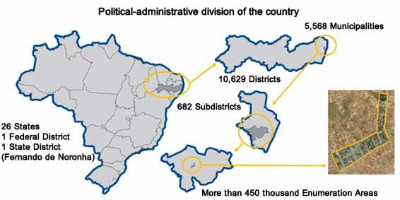
Source: Base Territorial de coleta do Censo 2022
Enumeration areas are classified into urban and rural ones, given the characteristics of occupation, use of the territory and the status of concentration and dispersion of housing units. These data collection and dissemination units are also classified as for the existence of specific data collection situations – subnormal clusters, indigenous and quilombola groups, agricultural villages, lodgings, camping sites, barracks, etc. – and their location in specific territories, such as Indigenous Lands, Quilombola Territories and Conservation. Maps for each enumeration area and for operational segments of the survey were produced – municipal maps, urban maps and special maps for Indigenous Lands and Quilombola Territories. Maps of enumeration areas were produced under two forms: one with a draft of streets and basic cartographic information and another one with very detailed orbital images for the area to be enumerated. A total of approximately 1 million maps will guide data collection teams all over the country.