For the first time ever, IBGE releases geographic coordinates of addresses in Brazil
The IBGE released today (2) the geographic coordinates of the addresses in the 2022 Census. This is the first time that the IBGE captures these data for all the households in Brazil. In the 2017 Census of Agriculture, the IBGE had already captured the addresses in the rural area, related to agricultural establishments. During the census operation in 2022, these coordinates allowed to follow up the work of the enumerators, as well as to follow up the evolution of the data collection.
The result of this work will integrate the National Address File for Statistical Purposes (CNEFE), the address base used by the IBGE not only in the Population Census, but also in other household surveys, like the Continuous National Household Sample Survey (PNAD), Consumer Expenditure Survey (POF) and National Survey of Demography and Health (PNDS).
As of today, the microdata are available for the society to apply them in a number of cases, like the localization of addresses in areas of risk of flood, landslides and scorched earth. Another possible use is to locate addresses in planning zones of the public administration, in conservation units and in areas of operation of a given enterprise.
The address coordinates can be used coupled with other databases, like risk areas pinpointed by the Geological Survey of Brazil (CPRM). “By using spatial filters, we manage to know how many private housing units are inside susceptible or impact areas, as well as other establishments, like health establishments and those under construction,” explains Eduardo Baptista, IBGE´s Manager of the Address File.
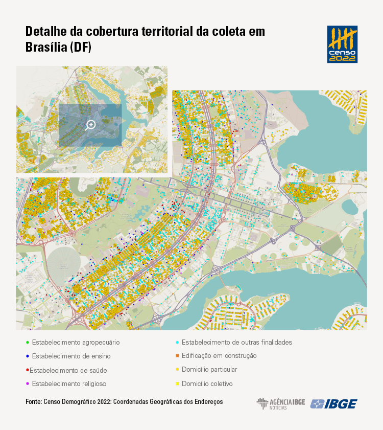
The geographic coordinates can be queried by type of address. “We have the latitude, longitude and type code, i.e., the purpose of the address. Therefore, users will know whether that point is either a private or collective housing unit, whether it is an agricultural, health or education establishment,” details Baptista. The geographic coordinates can be viewed in the Interactive Geographic Platform (PGI) and in the overview of the 2022 Census.
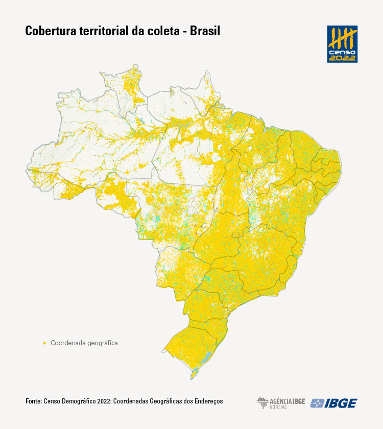
In the 2022 Census, 111.1 million geographic coordinates were registered for the address types identified in the census operation. Of this total, 109.9 million were validated after the data collection, which represents 98.9% of those coming from the original Census address file.
The manager explains that each geographic coordinate refers to an address type. “Each address has a coordinate. If the same place houses two address types, like a private housing unit and an agricultural establishment, then this same address will have two pairs of coordinates, with two different records in the file.”
Of the total addresses collected in the Census, 81.5% (or 90.6 million) were private housing units and 104.5 thousand (or 0.1%) were collective housing units. It is also possible to notice the types of establishments in Brazil: most of them fit in other purposes, with 11.7 million (or 10.5% of the total). For example, stores are in this group. On the other hand, education establishments were 264.4 thousand, health establishments, 247.5 thousand and religious establishments, 579.8 thousand. On their turn, buildings under construction were 3.5 million. The distribution of these address types among the Federation Units can be seen in the following table:
Total coordinates, according to address type - Brazil and Federation Units
| FU | Private housing unit | Collective housing unit | Agricultural establishment | Education establishment | Health establishment | Other-purpose establishment | Building under construction | Religious establishment |
|---|---|---|---|---|---|---|---|---|
| RO | 729244 | 866 | 98569 | 1893 | 1927 | 95697 | 29504 | 7670 |
| AC | 318942 | 379 | 31744 | 1881 | 769 | 40745 | 11464 | 4600 |
| AM | 1305348 | 2058 | 61722 | 7052 | 2738 | 194050 | 66868 | 19134 |
| RR | 211576 | 389 | 7101 | 1055 | 839 | 28134 | 9271 | 2150 |
| PA | 3053493 | 5423 | 201850 | 14150 | 6406 | 439526 | 152564 | 37758 |
| AP | 251566 | 516 | 5178 | 1112 | 796 | 37629 | 12681 | 3187 |
| TO | 654815 | 1166 | 62054 | 2351 | 1865 | 89668 | 31367 | 5151 |
| MA | 2588500 | 2542 | 95390 | 14444 | 6280 | 399659 | 125654 | 25374 |
| PI | 1418970 | 1474 | 176837 | 7410 | 4521 | 214266 | 57836 | 10107 |
| CE | 3822632 | 3373 | 162923 | 13850 | 8388 | 565846 | 149074 | 24556 |
| RN | 1500298 | 1567 | 43769 | 5010 | 3885 | 226756 | 54895 | 8823 |
| PB | 1804181 | 1150 | 102304 | 7605 | 5914 | 221743 | 72453 | 13536 |
| PE | 4092295 | 2884 | 206911 | 13373 | 9477 | 577168 | 193443 | 24931 |
| AL | 1321222 | 1042 | 48996 | 4923 | 3284 | 183224 | 55138 | 8736 |
| SE | 1006925 | 556 | 68702 | 3095 | 2199 | 127571 | 43213 | 6494 |
| BA | 6868847 | 7744 | 573839 | 28315 | 16347 | 1032896 | 466369 | 52939 |
| MG | 9561961 | 13864 | 615688 | 24184 | 32966 | 1292653 | 437593 | 59281 |
| ES | 1794597 | 2143 | 88061 | 4561 | 4672 | 228608 | 83012 | 15694 |
| RJ | 7709779 | 5684 | 47634 | 16499 | 15402 | 835701 | 276279 | 55222 |
| SP | 19623160 | 18316 | 199473 | 40746 | 56993 | 2325890 | 605209 | 83938 |
| PR | 5024225 | 4839 | 276214 | 12397 | 16498 | 609960 | 152740 | 25152 |
| SC | 3470459 | 4702 | 171363 | 8400 | 10447 | 406377 | 93210 | 16181 |
| RS | 5321610 | 6922 | 347724 | 13695 | 16467 | 611965 | 112064 | 26300 |
| MS | 1206036 | 3109 | 76139 | 2648 | 3709 | 165107 | 42915 | 8156 |
| MT | 1559872 | 6462 | 121381 | 4284 | 4570 | 216282 | 62134 | 10329 |
| GO | 3207511 | 4659 | 162304 | 7337 | 7872 | 438703 | 113581 | 18970 |
| DF | 1172001 | 688 | 4515 | 2175 | 2279 | 100889 | 30911 | 5429 |
| Brazil | 90600065 | 104517 | 4058385 | 264445 | 247510 | 11706713 | 3541442 | 579798 |
Digital data collection in the Census allows capturing geographic coordinates
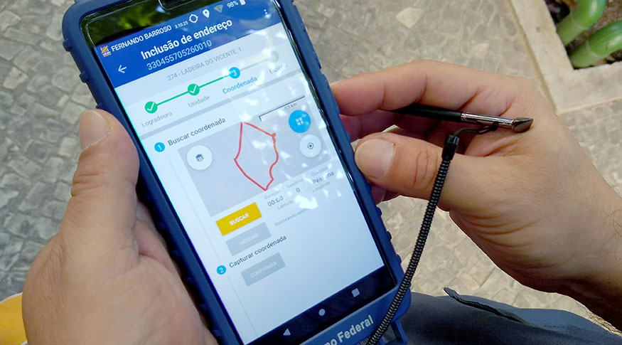
The geographic coordinates of the addresses were collected by more than 180 thousand enumerators, who worked in the 2022 Population Census, using their data collection mobile devices (DMCs). “These coordinates were collected during the confirmation or inclusion of addresses in the IBGE file. During their path along the enumeration areas, enumerators found the addresses on a list previously loaded in the DMCs. They confirmed those already existing and that were on the list and included those that were not. After the inclusion or confirmation of an address, the DMC application registered the geographic coordinate of that unit visited,” says Baptista.
He also tells how the collection of latitudes and longitudes in the field was used to supervise the work of the enumerators. “During the interview, whenever the questionnaire was opened, the application automatically collected some geographic coordinates in specific time lapses, so as the supervisors might check whether that interview was carried out in the proper place,” completes the manager.
In the CNEFE releases, the data are related only to the addresses, respecting the statistical confidentiality. “The IBGE Confidentiality Committee understood that the address data are not confidential. In this product, we are only releasing the coordinates with the FU and municipality codes, the maximum geographic division ever released by the IBGE,” says him. In the next release of CNEFE, scheduled for this year, other data will be included, such as the complete address with street name, number, complementation, locality and CEP.
More about the survey
The Population Census is the most complete statistical operation carried out in Brazil, covering all the households of the 5,570 Brazilian municipalities and collecting the geographic coordinates of the address types visited by the enumerators. The data can be viewed in the Interactive Geographic Platform (PGI) and in the overview of the 2022 Census.